Hello
I started on a new project yesterday – I do love a project! I thought I’d walk The Borders Abbeys Way and then go on and walk the other ‘ways’. There’s St Cuthbert’s Way and The Southern Upland Way and lots more I’m sure.


Yesterday was part one of the first section of the ‘way’. I used the Scottish Borders Council booklet appropriately named, ‘Borders Abbeys Way’, which divides the walk into convenient sections, and then divides them again – in case, like me, you don’t walk many miles in a day. Except they forgot to say in the booklet how many miles were in a subsection – I could have worked it out with the mileage scale on the map but I couldn’t be bothered – so I looked it up on-line. I must have been having a senior moment though because I confidently announced to Mr RR that it was just 6 miles……. it turned out to be 11! Ooops! My feet were hurting just a bit at the end ….and I went to bed very early! It was lovely though and the sun shone all day!
Enjoy reading
Ricketyrambler x
Jedburgh Abbey to Denholm (11.2 miles)
The Borders Abbeys Way is a 64.5 mile circular route which links the ruins of the four Border Abbeys at Jedburgh, Kelso, Melrose and Dryburgh and includes an earlier abbey in Selkirk. The first section starts at Jedburgh where the 12th century abbey was founded in 1138 by David I, Kings of the Scots.
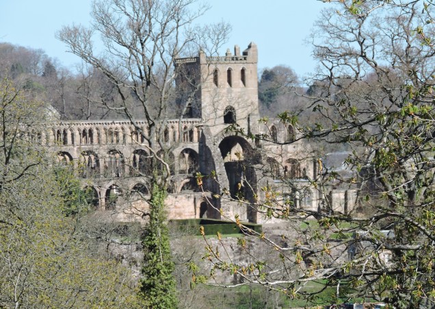
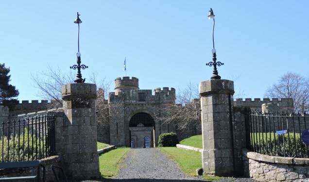
This being a linear route, we leave the car at the end of the walk in Denholm, and catch the bus into Jedburgh walking up the hill past the entrance to the Abbey (we’ll visit on another day) and the Castle Gaol – built on the site of the old castle and now a museum.
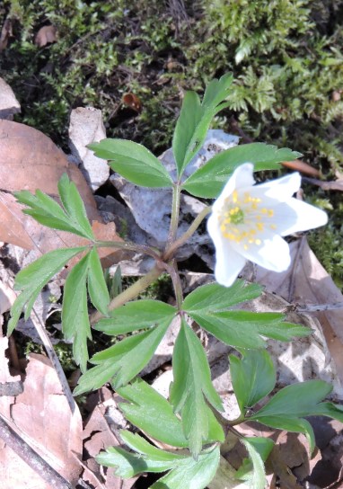
We follow the road beside the gaol as it goes downhill out-of-town, past some horses who seem to be enjoying a feast of wild garlic and on along a track which leads us steeply upwards. Fortunately, someone has been thoughtful enough to provide wooden steps alongside the deep mud which covers the hill. Along the way we see a carpet of wood anemones amid the wild garlic:
The route is easy to follow with good signage – we hardly need the book except for a bit of reassurance when a section between waymarks seems particularly long – which means we can concentrate on taking in the splendid views, listening to the skylarks and gazing at the sheep and lambs.


After a while we climb uphill again along a track beside a plantation – there’s an awful lot of uphill climbs in this walk already, I’m thinking.

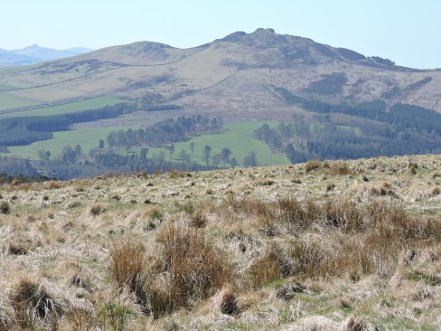
We’re walking between newly planted woodland on one side and sheep farming land on the other. Ahead of us is Black Law – a steep barren hill topped with radio masts, but behind us – glorious views right across rolling hills to The Cheviots in the Northumberland National Park


As we walk on between the hills and the sheep grazing on the moorland, there’s not a cloud in the sky and the sun is getting hot. I’m starting to want my lunch and we agree to stop at Bedrule, a little hamlet ahead of us.
Mr RR has commented on the lack of stiles so far – not a clever thing to say, as, from now until we stop there’s stile after stile after stile! Luckily some of them are beside gates that open but they’re all well maintained and not too difficult to clamber over. The ground underfoot is very wet and boggy though and it’s hard going for a while – quite a long while it turns out. It’s about now that I begin to wonder about this 6 miles that we’re supposed to be walking. Bedrule is about two-thirds of the way along the route according to the map – and we can’t even see it yet. We plod on across open moorland, between the grazing sheep and the swooping and squealing skylarks with our eyes on Rubers Law in the far distance.
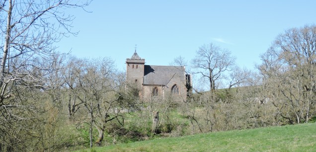
Eventually we find ourselves tramping down a stony farm track towards Bedrule where we take a short diversion to find the kirk in the hope that there will be somewhere we can sit down and have lunch.
Bedrule takes its name from the river down the road – Rule Water. It’s a tiny hamlet of a few houses with chickens roaming freely, sheep and lambs in an enclosure opposite the houses and a church with a very welcome bench and a stunning view over the valley below and Rubers Law ahead.


We’re glad to plonk ourselves down and rummage through our bags for lunch. I take the opportunity to rummage for my iPod as well and surruptitiously peek at the distance we’ve walked so far. 11.99km! I’m pretty sure that’s around 7 miles…..and we’re not near the end yet. I don’t tell Mr RR…..let him eat first I think.
So we sit and eat and stare at the view and wonder at the sudden change in the weather and ask ourselves why we wore so many clothes today. Hey ho!
Having filled up we take a stroll around the church – a rebuild in the 1800s. It’s cool inside and there are some lovely modern stained glass windows and surprisingly an upstairs seating area….


As we wander back through the hamlet I point out the lambs in the enclosure:
 A cute distraction whilst I mutter to Mr RR that I may have got the numbers wrong on the mileage front. I think he’d worked it out for himself anyway…..and the car is ahead of us….and that’s closer than going back! Onward!!
We’re going downhill now, towards the river, a surprisingly large river for such a little place. Looking back we have a lovely view of the church:
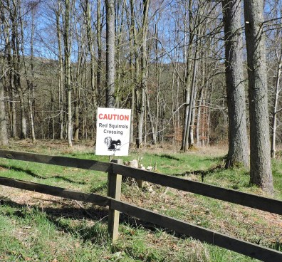
Across the bridge and uphill again pausing to smile at the roadsigns warning of Red Squirrels crossing.
Soon we’re back on moorland and walking over boggy ground towards Rubers Law before turning to the right and finally seeing Denholm ahead. Mr RR seems strangely reluctant to take a detour up the 424 metre high Law so we stride out across a few more fields and some stony tracks, thankfully downhill ones, and we’re back in the village. We don’t even stop for a cup of tea. I just want to change my boots and give my poor hot feet a rest. 11 miles! I’m so pleased I didn’t know that before we started but so glad that we did it.
‘It’s just a short stretch – the next part, maybe 5 miles’, I tell Mr RR. I’m not sure he believes me – but that’s for another day.
Thanks for reading!
Artwork for Ricketyrambler by Andrew Major
http://www.andrewmajorart.co.uk
http://www.artistsandillustrators.co.uk/Andrew-Major

So lovely to see your photos and read all the interesting facts about your area and the flora and fauna. The picture of your frog was fantastic! Have they spawned yet?
LikeLike